By Timothy Bottoms, January 2023
Abstract supplied by David Horton:
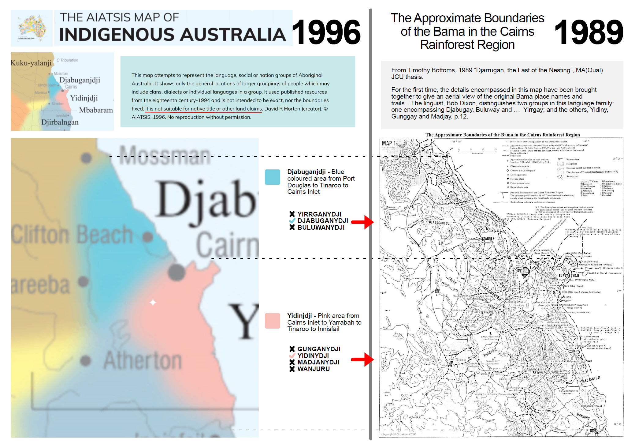
“Map showing all the Aboriginal groups of Australia, with organisation into regions. The groups (not “tribes”) are based on language, history, self-identification, culture, technology (the summation of all the research work in Australia up to that point), and are separated not by boundaries of hard lines, as in Tindale’s Map, but by fuzzy colours created by blending the colours of two adjacent groups. The regions were created, uniquely, by working from the individual groups and establishing where there was a distinct change in culture, language, social organisation, technology, economy, religion, kinship etc. Also considered was which groups combined together in large seasonal gatherings (ie within a region) and which areas marked historical reports of warfare (ie between regions). The result is a unique set (the first derived from the individual groups up, not imposed from the top down) of 18 regions which can be related to regions based on individual features.”
Yes, David Horton did create, literally, the supposed Indigenous map of Australia, and in the process has managed to exorcise a swathe of tribes.
On their website they promote the disclaimer:
The AIATSIS map serves as a visual reminder of the richness and diversity of Aboriginal and Torres Strait Islander Australia. It was created in 1996 as part of the Encyclopedia of Aboriginal Australia project and attempts to show language, social or nation groups based on published sources available up to 1994.
This unfortunately is totally misleading. I submitted my MA(Qual) in March 1990, where I mapped the tribes of the Cairns rainforest region, and where Horton excludes the Yirrganydji, Buluwanydji, Gungganydji, Madjanydji and the Muluridji (under the new format, this tribe has to call itself ‘Western Kuku Yalanji’).
So the AIASTSIS map is a misnomer. Horton identifies Djabugay as a language, but ignores Yirrganydji and Buluwanydji, which while related, are separate tribal identities. Horton identifies Yidiny as a language, but ignores Gunggay, Madjanydji and Ngatjan, which while related are separate tribal identities. Horton identifies Kuku Yalanji as a language, but ignores Muluridji, which while related are separate tribal identities.
To Aboriginal tribes in Far North Queensland (and I’m sure it’s happened elsewhere in Australia), despite the disclaimer that ‘This [map] is not to be used for Native Title’ those tribes who appear on this map have taken the advantages that come with the recognition of being on the map! Why else would Indigenous people, who have grown up as Yirrganydji, Buluwanydji, Gungganydji, Madjanydji and the Muluridji, suddenly find that the peak body that ostensibly represents Aboriginal research, negates them entirely.
The ‘Studies’ part of Australian Institute of Aboriginal and Torres Strait Islander Studies Act 1989, is a furphy. Horton doctored the tribal groupings in FNQ to suit other purposes, i.e. reducing tribes in order not to formally recognise those not listed in their map. So AIATSIS is basically doing the bidding of Federal and State Governments and precluded what Horton decided back in 1996.
This is atrocious when you take in account what Aboriginal people have been through: introduced diseases, massacres, then the autocratic control of the Department of Aboriginal Affairs and the decisive racism that has pervaded their missions etc, until 1986 and the freeing up from the various Acts that control them. AIATSIS is doing the work of Governments and should be thoroughly ashamed of what they are doing.
They should scrap the false Horton map and give voice to those tribal groups that they have omitted! Australian history and reconciliation will surely be richer for it.